
Useful Apps that help in designing solar power
Designing solar power solutions needs to be accurate specially on the small details. One of the common tools being use is the compass. This is to check and ensure that the solar panels will be facing the right direction.
If You’re familiar with solar panel installation or must have read about it, i’m sure you’ve heard alot about the “solar panels should be facing south”. This is true then if you’re living in the northern hemisphere. Like here in the Philippines, we’re about 14.6 degrees above the equator. Meaning, solar panels facing that direction yields higher output, which the case is 14.6 degrees south and more often than not, this is the usual.
So, basically the idea of facing south is the general standard here in the Philippines. But there are some special cases ie. power demands are higher during morning or afternoon, or for some specific time and months. This will need special attention and details. To help us with this situation, we found this app called Sun Surveyor Pro.
Sun Surveyor Pro takes the mystery out of the sunrise, sunset and magic hours, helping solar panel designers, photographers and filmmakers scout the best locations, plan effectively, and get the perfect spot. Solar Industry (PV) Professionals, architects, real estate agents, and gardeners will also find a wealth of empowering, interactive features.
The 3D Compass and detailed Ephemeris provide a wealth of information about the largest natural light source in the galaxy:
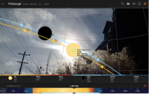
– Predict and plan for the golden hour, blue hour and every sunrise & sunset
– Visualize the sun’s path throughout the day or through the year
Additional features:
– Visual time machine – take a quick glance at the light for a day, or dial in desired compositions easily
– Twilight times – civil, nautical, astronomical
– Solstice and Equinox visualization
– Sun shadow information – calculate the length of shadows cast by objects
– Magnetic declination compensation
Check out the Full Version of Sun Surveyor for more:
– Live Camera View – augmented reality projections of the sun and moon paths; pinpoint the time the sun or moon will be at a particular location in the sky
– Interactive Map View – plan a remote shot or PV array placement, interact with a top-down perspective of sun and moon paths and events
– Street View Panoramas – 360 degree spherical panoramas with selected sun, moon and milky way events overlaid, where available
– Moon Information: moon position, moonrise, moonset, moon phases, apogee, perigee, distance and a Super Moon finder
– Show clients the quality and quantity of seasonal sunlight at a remote location
– Understand potential shade of surroundings and discover any obstructions
– Create images of the summer and winter Solstice & Equinox paths for a site
– Prepare night photography shots with the Milky Way & star trail features
– Offline usage (excludes Map View, Street View) – enter coordinates, save & load locations with no data connection or GPS available
– Measure distance, and difference between elevations, and vertical angle differentials with the Map view
– Import and export Google Earth .kmz/.kml locations